| Introduction | Samoa |
|
Background:
|
New Zealand occupied the German protectorate of Western Samoa at the outbreak of World War I in 1914. It continued to administer the islands as a mandate and then as a trust territory until 1962, when the islands became the first Polynesian nation to reestablish independence in the 20th century. The country dropped the "Western" from its name in 1997. |
| Geography | Samoa |
|
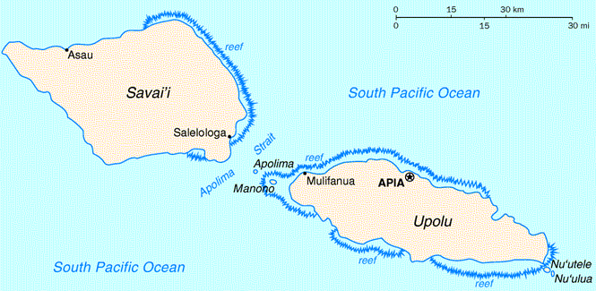
Location:
|
Oceania, group of islands in the South Pacific Ocean, about one-half of the way from Hawaii to New Zealand |
|
Geographic coordinates:
|
13 35 S, 172 20 W |
|
Map references:
|
Oceania |
|
Area:
|
total: 2,944 sq km
land: 2,934 sq km water: 10 sq km |
|
Area - comparative:
|
slightly smaller than Rhode Island |
|
Land boundaries:
|
0 km |
|
Coastline:
|
403 km |
|
Maritime claims:
|
territorial sea: 12 nm
exclusive economic zone: 200 nm |
|
Climate:
|
tropical; rainy season (November to April), dry season (May to October) |
|
Terrain:
|
two main islands (Savaii, Upolu) and several smaller islands and uninhabited islets; narrow coastal plain with volcanic, rocky, rugged mountains in interior |
|
Elevation extremes:
|
lowest point: Pacific Ocean 0 m
highest point: Mauga Silisili (Savaii) 1,857 m |
|
Natural resources:
|
hardwood forests, fish, hydropower |
|
Land use:
|
arable land: 21.2%
permanent crops: 24.38% other: 54.42% (2001) |
|
Irrigated land:
|
NA |
|
Natural hazards:
|
occasional typhoons; active volcanism |
|
Environment - current issues:
|
soil erosion, deforestation, invasive species, overfishing |
|
Environment - international agreements:
|
party to: Biodiversity, Climate Change, Climate Change-Kyoto Protocol, Desertification, Hazardous Wastes, Law of the Sea, Ozone Layer Protection
signed, but not ratified: none of the selected agreements |
|
Geography - note:
|
occupies an almost central position within Polynesia |
| People | Samoa |
|
Population:
|
177,287 (July 2005 est.) |
|
Age structure:
|
0-14 years: 27.2% (male 24,517/female 23,660)
15-64 years: 66.4% (male 73,495/female 44,208) 65 years and over: 6.4% (male 5,204/female 6,203) (2005 est.) |
|
Median age:
|
total: 24.59 years
male: 27.42 years female: 21.42 years (2005 est.) |
|
Population growth rate:
|
-0.23% (2005 est.) |
|
Birth rate:
|
15.95 births/1,000 population (2005 est.) |
|
Death rate:
|
6.54 deaths/1,000 population (2005 est.) |
|
Net migration rate:
|
-11.73 migrant(s)/1,000 population (2005 est.) |
|
Sex ratio:
|
at birth: 1.05 male(s)/female
under 15 years: 1.04 male(s)/female 15-64 years: 1.66 male(s)/female 65 years and over: 0.84 male(s)/female total population: 1.39 male(s)/female (2005 est.) |
|
Infant mortality rate:
|
total: 27.71 deaths/1,000 live births
male: 32.68 deaths/1,000 live births female: 22.48 deaths/1,000 live births (2005 est.) |
|
Life expectancy at birth:
|
total population: 70.72 years
male: 67.93 years female: 73.65 years (2005 est.) |
|
Total fertility rate:
|
3.01 children born/woman (2005 est.) |
|
HIV/AIDS - adult prevalence rate:
|
NA |
|
HIV/AIDS - people living with HIV/AIDS:
|
12 |
|
HIV/AIDS - deaths:
|
3 |
|
Nationality:
|
noun: Samoan(s)
adjective: Samoan |
|
Ethnic groups:
|
Samoan 92.6%, Euronesians 7% (persons of European and Polynesian blood), Europeans 0.4% |
|
Religions:
|
Congregationalist 34.8%, Roman Catholic 19.6%, Methodist 15%, Latter-Day Saints 12.7%, Assembly of God 6.6%, Seventh-Day Adventist 3.5%, other Christian 4.5%, Worship Centre 1.3%, other 1.7%, unspecified 0.1% (2001 census) |
|
Languages:
|
Samoan (Polynesian), English |
|
Literacy:
|
definition: age 15 and over can read and write
total population: 99.7% male: 99.6% female: 99.7% (2003 est.) |
| Government | Samoa |
|
Country name:
|
conventional long form: Independent State of Samoa
conventional short form: Samoa former: Western Samoa |
|
Government type:
|
mix of parliamentary democracy and constitutional monarchy |
|
Capital:
|
Apia |
|
Administrative divisions:
|
11 districts; A'ana, Aiga-i-le-Tai, Atua, Fa'asaleleaga, Gaga'emauga, Gagaifomauga, Palauli, Satupa'itea, Tuamasaga, Va'a-o-Fonoti, Vaisigano |
|
Independence:
|
1 January 1962 (from New Zealand-administered UN trusteeship) |
|
National holiday:
|
Independence Day Celebration, 1 June (1962); note - 1 January 1962 is the date of independence from the New Zealand-administered UN trusteeship, 1 June 1962 is the date that independence is celebrated |
|
Constitution:
|
1 January 1962 |
|
Legal system:
|
based on English common law and local customs; judicial review of legislative acts with respect to fundamental rights of the citizen; has not accepted compulsory ICJ jurisdiction |
|
Suffrage:
|
21 years of age; universal |
|
Executive branch:
|
chief of state: Chief Tanumafili II MALIETOA (cochief of state from 1 January 1962 until becoming sole chief of state 5 April 1963)
head of government: Prime Minister Sailele Malielegaoi TUILA'EPA (since 1996); note - TUILA'EPA served as deputy prime minister from 1992 and assumed the duties of acting prime minister in 1996, when former Prime Minister TOFILAU Eti Alesana resigned in poor health; TUILA'EPA was confirmed as prime minister (November 1998) after TOFILAU died; Deputy Prime Minister MISA Telefoni (since 2001) cabinet: Cabinet consists of 12 members, appointed by the chief of state on the prime minister's advice elections: upon the death of Chief Tanumafili II MALIETOA, a new chief of state will be elected by the Legislative Assembly to serve a five-year term; following legislative elections, the leader of the majority party is usually appointed prime minister by the chief of state with the approval of the Legislative Assembly |
|
Legislative branch:
|
unicameral Legislative Assembly or Fono (49 seats - 47 elected by voters affiliated with traditional village-based electoral districts, 2 elected by independent, mostly non-Samoan or part-Samoan, voters who cannot, (or choose not to) establish a village affiliation; only chiefs (matai) may stand for election to the Fono from the 47 village-based electorates; members serve five-year terms)
elections: election last held 3 March 2001 (next election to be held not later than March 2006) election results: percent of vote by party - NA%; seats by party - HRPP 30, SNDP 13, independents 6 |
|
Judicial branch:
|
Court of Appeal; Supreme Court; District Court; Land and Titles Court |
|
Political parties and leaders:
|
Christian Democratic Party [leader NA]; Human Rights Protection Party or HRPP [Sailele Malielegaoi TUILA'EPA, chairman]; Samoan Democratic United Party or SDUP [LE MAMEA Ropati, chairman] (opposition) |
|
Political pressure groups and leaders:
|
NA |
|
International organization participation:
|
ACP, AsDB, C, FAO, G-77, IBRD, ICAO, ICCt, ICFTU, ICRM, IDA, IFAD, IFC, IFRCS, IMF, IMO, IOC, ITU, MIGA, OPCW, PIF, Sparteca, UN, UNCTAD, UNESCO, UPU, WCO, WHO, WIPO, WMO, WTO (observer) |
|
Diplomatic representation in the US:
|
chief of mission: Ambassador Aliioaiga Feturi ELISAIA
chancery: 800 Second Avenue, Suite 400D, New York, NY 10017 telephone: [1] (212) 599-6196, 6197 FAX: [1] (212) 599-0797 |
|
Diplomatic representation from the US:
|
chief of mission: US Ambassador to New Zealand is accredited to Samoa
embassy: Accident Compensation Board (ACB) Building, 5th Floor, Apia mailing address: P. O. Box 3430, Apia telephone: [685] 21631/22696 FAX: [685] 22030 |
|
Flag description:
|
red with a blue rectangle in the upper hoist-side quadrant bearing five white five-pointed stars representing the Southern Cross constellation |
| Economy | Samoa |
|
Economy - overview:
|
The economy of Samoa has traditionally been dependent on development aid, family remittances from overseas, agriculture, and fishing. The country is vulnerable to devastating storms. Agriculture employs two-thirds of the labor force, and furnishes 90% of exports, featuring coconut cream, coconut oil, and copra. The manufacturing sector mainly processes agricultural products. The decline of fish stocks in the area is a continuing problem. Tourism is an expanding sector, accounting for 25% of GDP; about 88,000 tourists visited the islands in 2001. One factory in the Foreign Trade Zone employs 3,000 people to make automobile electrical harnesses for an assembly plant in Australia. The Samoan Government has called for deregulation of the financial sector, encouragement of investment, and continued fiscal discipline, meantime protecting the environment. Observers point to the flexibility of the labor market as a basic strength for future economic advances. Foreign reserves are in a relatively healthy state, the external debt is stable, and inflation is low. |
|
GDP (purchasing power parity):
|
$1 billion (2002 est.) |
|
GDP - real growth rate:
|
5% (2002 est.) |
|
GDP - per capita:
|
purchasing power parity - $5,600 (2002 est.) |
|
GDP - composition by sector:
|
agriculture: 14%
industry: 23% services: 63% (2001 est.) |
|
Labor force:
|
90,000 (2000 est.) |
|
Labor force - by occupation:
|
NA |
|
Unemployment rate:
|
NA; note - substantial underemployment |
|
Population below poverty line:
|
NA |
|
Household income or consumption by percentage share:
|
lowest 10%: NA
highest 10%: NA |
|
Inflation rate (consumer prices):
|
4% (2001 est.) |
|
Budget:
|
revenues: $105 million
expenditures: $119 million, including capital expenditures of NA (2001-02) |
|
Agriculture - products:
|
coconuts, bananas, taro, yams, coffee, cocoa |
|
Industries:
|
food processing, building materials, auto parts |
|
Industrial production growth rate:
|
2.8% (2000) |
|
Electricity - production:
|
122 million kWh (2002) |
|
Electricity - production by source:
|
fossil fuel: 58%
hydro: 42% nuclear: 0% other: 0% (2001) |
|
Electricity - consumption:
|
113.5 million kWh (2002) |
|
Electricity - exports:
|
0 kWh (2002) |
|
Electricity - imports:
|
0 kWh (2002) |
|
Oil - production:
|
0 bbl/day (2001 est.) |
|
Oil - consumption:
|
1,000 bbl/day (2001 est.) |
|
Oil - exports:
|
NA |
|
Oil - imports:
|
NA |
|
Exports:
|
$14 million f.o.b. (2002) |
|
Exports - commodities:
|
fish, coconut oil and cream, copra, taro, automotive parts, garments, beer |
|
Exports - partners:
|
Australia 67.2%, US 5.7%, Indonesia 5.3% (2004) |
|
Imports:
|
$113 million f.o.b. (2002) |
|
Imports - commodities:
|
machinery and equipment, industrial supplies, foodstuffs |
|
Imports - partners:
|
New Zealand 25.1%, Fiji 21.5%, Taiwan 9.1%, Australia 8.9%, Singapore 8.5%, Japan 7.5%, US 4.7% (2004) |
|
Debt - external:
|
$197 million (2000) |
|
Economic aid - recipient:
|
$42.9 million (1995) |
|
Currency (code):
|
tala (SAT) |
|
Currency code:
|
SAT (former WST code is still in wide use) |
|
Exchange rates:
|
tala per US dollar - 2.7807 (2004), 2.9732 (2003), 3.3763 (2002), 3.478 (2001), 3.2864 (2000) |
|
Fiscal year:
|
June 1 - May 31 |
| Communications | Samoa |
|
Telephones - main lines in use:
|
11,800 (2002) |
|
Telephones - mobile cellular:
|
2,700 (2002) |
|
Telephone system:
|
general assessment: adequate
domestic: NA international: country code - 685; satellite earth station - 1 Intelsat (Pacific Ocean) |
|
Radio broadcast stations:
|
AM 2, FM 5, shortwave 0 (2004) |
|
Radios:
|
174,849 (1997) |
|
Television broadcast stations:
|
2 (2002) |
|
Televisions:
|
8,634 (1999) |
|
Internet country code:
|
.ws |
|
Internet hosts:
|
8,225 (2003) |
|
Internet Service Providers (ISPs):
|
2 (2000) |
|
Internet users:
|
4,000 (2002) |
| Transportation | Samoa |
|
Highways:
|
total: 790 km
paved: 332 km unpaved: 458 km (1999 est.) |
|
Ports and harbors:
|
Apia |
|
Merchant marine:
|
total: 1 ships (1,000 GRT or over) 7,091 GRT/8,127 DWT
by type: cargo 1 foreign-owned: 1 (Germany 1) (2005) |
|
Airports:
|
4 (2004 est.) |
|
Airports - with paved runways:
|
total: 3
2,438 to 3,047 m: 1 under 914 m: 2 (2004 est.) |
|
Airports - with unpaved runways:
|
total: 1
under 914 m: 1 (2004 est.) |
| Military | Samoa |
|
Military branches:
|
no regular armed services; Samoa Police Force |
|
Military expenditures - dollar figure:
|
NA |
|
Military expenditures - percent of GDP:
|
NA |
|
Military - note:
|
Samoa has no formal defense structure or regular armed forces; informal defense ties exist with NZ, which is required to consider any Samoan request for assistance under the 1962 Treaty of Friendship |
| Transnational Issues | Samoa |
|
Disputes - international:
|
none |
Sources: The CIA World Fact Book and other public domain Internet sites